
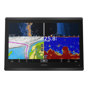
The Garmin GPSMAP 8616xsv pairs a 16a ^2 full HD IPS touchscreen with broad viewing angles and sunlight readability-even through polarized lenses-for reliable clarity in any conditions. It comes preloaded with Garmin Navionics+ inland and coastal mapping with Auto Guidance+ and includes one year of downloadable daily updates. Built-in sonar support includes dual-channel 1kW CHIRP, ClearVAoe, SideVAoe, and compatibility with Garmin Live Sonar (transducers sold separately). With full networking via NMEA 2000, NMEA 0183, Garmin Marine Network, ANT+, Bluetooth, and Wi-Fi, the 8616xsv supports system expansion across radar, cameras, autopilot, and third-party devices using OneHelm integration. SmartMode station controls let you access radar, sonar, and more with a single tap-ideal for high-pressure situations like docking or chasing breaking fish. The chartplotter also supports SailAssist functions, Power-Pole integration, the ActiveCaptain app, and remote operation with the optional GRID 20 controller. From tournament-level navigation to system-wide integration, the GPSMAP 8616xsv delivers pro-grade control and clarity for serious anglers and captains alike. General Dimension: 15.1' x 10.3' x 3' (38.5 cm x 26.3 cm x 7.6 cm) Weight: 9.6 lbs. (4.4 kg) Water Rating: IPX7 Touchscreen: Yes Display Type: FHD, IPS Display Size: 13.6' x 7.7'; 15.6' diagonal, 34.5 cm x 19.5 cm; 39.7 cm diagonal Display Resolution: 1920 x 1080 pixels Mounting Options: Flat and flush, bail with optional accessory (Garmin does not offer any hardware or accessories for a flat-mount installation. Professional tools and knowledge is required.) Input: Touchscreen Maps & Memory Accepts Data Cards: 2 microSD cards Waypoints: 5000 Track Points: 50,000 Tracks: 50 saved tracks Navigation Routes: 100 Sensors GPS: Yes GLONASS: Yes Galileo: Yes Built-in Receiver: Yes Receiver: 10 Hz NMEA 2000 Compatible: Yes NMEA 0183 Compatible: Yes Supports WAAS: Yes Built-in Maps Built-in Auto Guidance+: Yes Garmin Navionics+ Inland & Coastal: Yes Tide Tables: Yes Optional Map Support Garmin Navionics+: Yes Garmin Navionics Vision+: Yes TOPO 100K: Yes Standard Mapping: Yes Garmin Quickdraw Contours: Yes Raster Chart Support: Yes Chartplotter Features Smart Mode Compatible: Yes AIS: Yes DSC: Yes Supports Fusion-Link Compatible Radios: Yes GSD Black Box Sonar Support: Yes GCV Black Box Sonar Support: Yes ActiveCaptain Compatible: Yes GRID (Garmin Remote Input Device) Compatible: Yes Wireless Remote Compatible: Yes Sailing Features: Yes Spoken Audio Alerts: Yes Onehelm Support: Yes Electrical Features Power Input: 10 to 32 Vdc Typical Current Draw at 12 Vdc: 1.3 A Maximum Current Draw at 12 Vdc: 6.0 A Maximum Power Usage at 10 Vdc: 52.1W Sonar Features Displays Sonar: Yes Power Output: 1 kW Traditional Sonar (Dual Frequency/Beam): Built-in (dual channel CHIRP, 70/83/200 kHz, L, M, H CHIRP) ClearVü: Yes Built-in 260/455/800/1000/1200 kHz SideVü: Yes Built-in 260/455/800/1000/1200 kHz Panoptix Sonar: Yes LiveScope: Yes Connections NMEA 2000 Ports: 1 NMEA 0183 Input (Rx) Ports: 1 NMEA 0183 Output (Tx) Ports: 1 Video Input Ports: 1 (BNC Composite), 1 HDMI (HDCP compliant) Video Output Ports: 1 HDMI J1939 Ports: 1 Garmin Marine Network Ports: 2 8-Pin Transducer Ports: Yes 12-Pin Transducer Ports: Yes USB Ports: Yes BLUETOOTH Pairing: Yes ANT+ (Connectivity): Yes Garmin Wi-Fi Network (Local Connection): Yes In the Box: PART NUMBER010-02093-51: GPSMAP 8616xsv Power Cable NMEA 2000 Drop Cable NMEA 2000 T-connector Flush Mount Kit with Gasket Sun Cover Trim Piece Snap Covers Documentation
Price: $6299.99 from FishUSA
| Merchant | Price | |
|---|---|---|
| FishUSA | $6299.99 | Visit Store |
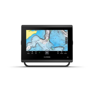
The Garmin GPSMAP 723xsv brings clear IPS touchscreen control and fast processing to your helm, keeping charts, sonar, and engine data sharp while you work weedlines for largemouth, follow contour breaks for walleye, or trim sails and hold a steady course...
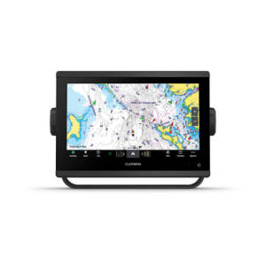
The Garmin GPSMAP 743xsv delivers responsive helm control in a compact footprint, combining an upgraded IPS display and powerful processing to keep charts, sonar, and engine data sharp while you work rock piles for smallmouth, troll for salmon, or trim...
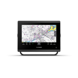
The Garmin GPSMAP 923xsv brings upgraded IPS touchscreen clarity and fast processing to your helm, keeping charts, sonar, and engine data responsive while you work offshore humps for walleye, follow bait schools for striped bass, or trim sails and hold...