
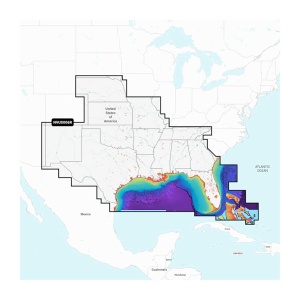
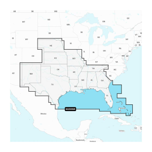
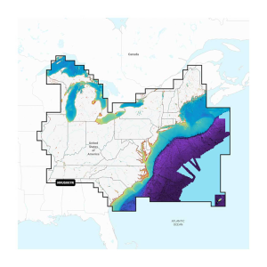
The Garmin Navionics Vision+ cartography stands out with its comprehensive coverage and advanced features, making it a top choice for anglers and boaters. Designed for both coastal and inland waterways, these charts offer high-resolution satellite imagery, 3D views, and integrated Auto Guidance+ technology. These unique features ensure precise route planning and safe passage. Each microSD/SD card includes a one-year subscription and is available in various regional choices, including: U.S. West - Inland and Coastal Marine Charts, U.S. East - Lakes, Rivers and Coastal Marine Charts, U.S. South - Lakes, Rivers and Coastal Marine Charts, U.S. North & Great Lakes - Lakes, Rivers and Coastal Marine Charts, Canada, West & Alaska - Lakes, Rivers and Coastal Marine Charts, and Canada, East & Great Lakes - Lakes, Rivers and Coastal Marine Charts. The charts are compatible with a wide range of Garmin devices. The user-friendly interface and advanced features such as relief shading, shallow water shading, and coastal high-resolution imagery provide a clear and detailed view of your surroundings, helping you navigate confidently and precisely.Integrated Garmin and Navionics content, with an updated color palette and Navionics style appearance, provides exceptional coverage, clarity, and detailEasy access to daily chart updates is available via the ActiveCaptain appBuilt-in Auto Guidance+ technology uses your desired depth and overhead clearance, along with chart data and frequently traveled routes, to calculate a suggested path to follow from dock to dockHigh-resolution relief shading feature combines color and shadow to give you an easy-to-interpret, clearer view of bottom structure than contour lines aloneHigh-resolution satellite imagery overlaid with navigational charts gives you a realistic view of your surroundings - ideal for entering unfamiliar harbors or portsAerial photography of ports, bridges, docks, navigational landmarks, and more provides a better sense of your surroundings above the waterlineSide scan images capture submerged features such as fallen timber, fish attractors, wrecks, potential hazards, and more on select U.S. lakesSonar imagery reveals bottom hardness clearly and in color, highlighting both subtle and dramatic transition areas on select U.S. lakesUnique 3D views, such as MarinerEye and FishEye, provide additional perspective both above and below the water lineNOAA raster cartography is available as a free downloadable feature via the ActiveCaptain appDepth range shading lets you select up to 10 color-shaded options and view your target depths at a glanceFor improved fishing charts and navigation, up to 1' contours provide a more detailed depiction of the bottom structureShallow water shading feature highlights depths up to a user-defined level to aid navigationActiveCaptain community content provides valuable POIs, recommendations, and advice from boaters with firsthand experience of the local environmentAvailable on microSD/SD cards (each region sold separately); cartography updates are available via annual renewable subscription (the first year of updates is included)
Price: $249.99 from FishUSA
| Merchant | Price | |
|---|---|---|
| FishUSA | $249.99 | Visit Store |
The Garmin Navionics+ cartography, designed for Garmin devices, provides detailed and up-to-date marine and lake charts, perfect for coastal and inland navigation. These charts offer integrated Garmin and Navionics content, ensuring exceptional coverage,...
The Garmin Navionics Vision+ cartography stands out with its comprehensive coverage and advanced features, making it a top choice for anglers and boaters. Designed for both coastal and inland waterways, these charts offer high-resolution satellite imagery,...
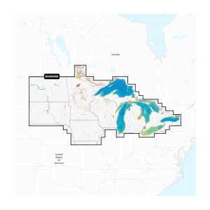
The Garmin Navionics Vision+ cartography stands out with its comprehensive coverage and advanced features, making it a top choice for anglers and boaters. Designed for both coastal and inland waterways, these charts offer high-resolution satellite imagery,...