
))/1754602.json)
Combiningarge-scaleandscape maps and recreation guides, the Benchmark Maps Road & Recreation Atlas offers an invaluable resource for adventure planning and exploration. Compiled by Benchmark's team of field checkers, cartographers, and
))/2151136.json)
Combiningarge-scaleandscape maps and recreation guides, the Benchmark Maps Road & Recreation Atlas offers an invaluable resource for adventure planning and exploration. Compiled by Benchmark's team of field checkers, cartographers, and
))/3047521.json)
Combiningarge-scaleandscape maps and recreation guides, the Benchmark Maps Road & Recreation Atlas offers an invaluable resource for adventure planning and exploration. Compiled by Benchmark's team of field checkers, cartographers, and
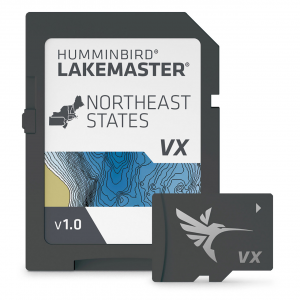
Humminbird LakeMaster Digital Maps, featuring standard VX Technology, offer more than 13,000 lake maps across 13 regions in North America. Updated LakeMaster Maps SD Cards provide enhanced underwater mapping, detailed shorelines, and adjustable color...
))/4829892.json)
The onXmaps HUNT State Maps Micro SD Card provides hunters with maps of a specific state to ultimately enhance hunting success. You can use the card with a smartphone, computer, or Garmin GPS unit. onXmaps displays 24K topo, color-coded publ
))/4064242.json)
Benchmark Maps Folded State Recreation Map provides full state map with dynamic details. This folding state map contains the full state on 1 side, complete with publicands, extensive highway detail, point-to-point mileages, recreation attr
))/2151137.json)
Combiningarge-scaleandscape maps and recreation guides, the Benchmark Maps Road & Recreation Atlas offers an invaluable resource for adventure planning and exploration. Compiled by Benchmark's team of field checkers, cartographers, and
))/3047524.json)
Combiningarge-scaleandscape maps and recreation guides, the Benchmark Maps Road & Recreation Atlas offers an invaluable resource for adventure planning and exploration. Compiled by Benchmark's team of field checkers, cartographers, and
))/1859334.json)
Don't settle for map cards that only offer a quick once-over of water bodies. The Garmin BlueChart g2 HD Chartplotter Maps microSD Card delivers an advanced offering unlike any other. Only a Garmin map card stands out as de
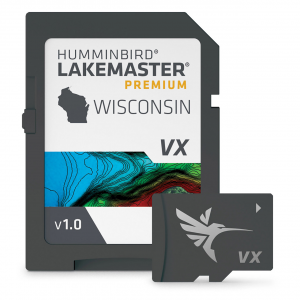
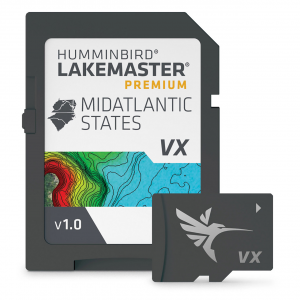
Humminbird LakeMaster Premium Digital Maps give an added advantage over standard LakeMaster Maps, supplying you with additional features, 2D Shaded Relief, and Aerial Imagery! The 2D Shaded Relief makes bottom detail and depth changes even easier to spot....
))/3047525.json)
Combiningarge-scaleandscape maps and recreation guides, the Benchmark Maps Road & Recreation Atlas offers an invaluable resource for adventure planning and exploration. Compiled by Benchmark's team of field checkers, cartographers, and
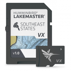
Humminbird LakeMaster Digital Maps, featuring standard VX Technology, offer more than 13,000 lake maps across 13 regions in North America. Updated LakeMaster Maps SD Cards provide enhanced underwater mapping, detailed shorelines, and adjustable color...
))/2429842.json)
The onXmaps HUNT State Maps Micro SD Card provides hunters with maps of a specific state to ultimately enhance hunting success. You can use the card with a smartphone, computer, or Garmin GPS unit. onXmaps displays 24K topo, color-coded publ
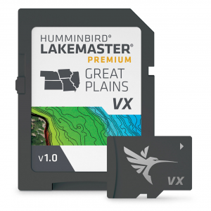
Humminbird LakeMaster Premium Digital Maps give an added advantage over standard LakeMaster Maps, supplying you with additional features, 2D Shaded Relief, and Aerial Imagery! The 2D Shaded Relief makes bottom detail and depth changes even easier to spot....
))/2429861.json)
The onXmaps HUNT State Maps Micro SD Card provides hunters with maps of a specific state to ultimately enhance hunting success. You can use the card with a smartphone, computer, or Garmin GPS unit. onXmaps displays 24K topo, color-coded publ
Humminbird LakeMaster Premium Digital Maps give an added advantage over standard LakeMaster Maps, supplying you with additional features, 2D Shaded Relief, and Aerial Imagery! The 2D Shaded Relief makes bottom detail and depth changes even easier to spot....
))/2429846.json)
The onXmaps HUNT State Maps Micro SD Card provides hunters with maps of a specific state to ultimately enhance hunting success. You can use the card with a smartphone, computer, or Garmin GPS unit. onXmaps displays 24K topo, color-coded publ
))/2429840.json)
The onXmaps HUNT State Maps Micro SD Card provides hunters with maps of a specific state to ultimately enhance hunting success. You can use the card with a smartphone, computer, or Garmin GPS unit. onXmaps displays 24K topo, color-coded publ
))/2429844.json)
The onXmaps HUNT State Maps Micro SD Card provides hunters with maps of a specific state to ultimately enhance hunting success. You can use the card with a smartphone, computer, or Garmin GPS unit. onXmaps displays 24K topo, color-coded publ
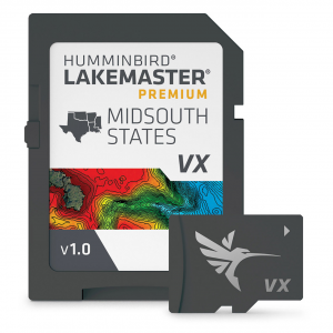
Humminbird LakeMaster Premium Digital Maps give an added advantage over standard LakeMaster Maps, supplying you with additional features, 2D Shaded Relief, and Aerial Imagery! The 2D Shaded Relief makes bottom detail and depth changes even easier to spot....
))/2429851.json)
The onXmaps HUNT State Maps Micro SD Card provides hunters with maps of a specific state to ultimately enhance hunting success. You can use the card with a smartphone, computer, or Garmin GPS unit. onXmaps displays 24K topo, color-coded publ
))/2429860.json)
The onXmaps HUNT State Maps Micro SD Card provides hunters with maps of a specific state to ultimately enhance hunting success. You can use the card with a smartphone, computer, or Garmin GPS unit. onXmaps displays 24K topo, color-coded publ
))/3732046.json)
Keep connected and on track with the Garmin Rino 750t Handheld 2-Way Radio with GPS and TOPO Maps. This Garmin 2-way radio boasts a range up to 20 miles, allowing communication by voice or unit-to-unit text messaging. GPS and GLONAS
))/3047522.json)
Combiningarge-scaleandscape maps and recreation guides, the Benchmark Maps Road & Recreation Atlas offers an invaluable resource for adventure planning and exploration. Compiled by Benchmark's team of field checkers, cartographers, and
))/2429864.json)
The onXmaps HUNT State Maps Micro SD Card provides hunters with maps of a specific state to ultimately enhance hunting success. You can use the card with a smartphone, computer, or Garmin GPS unit. onXmaps displays 24K topo, color-coded publ