
))/3079689.json)
Hey hikers, backpackers, and other wilderness explorers, the National Geographic Trails Illustrated Topographic Map Guide Series is the resource you'll want in your backpack while wandering unfamiliar trails. Certified Backcountry Tough, this fold-
))/3079700.json)
Fish smarter with the help of the information packed inside the National Geographic Fishing and River Recreation Map Guide Series Maps. Each one includes detailed river maps at a scale of 1 for every half mile. At this scale, every bend and
))/3079686.json)
Hey hikers, backpackers, and other wilderness explorers, the National Geographic Trails Illustrated Topographic Map Guide Series is the resource you'll want in your backpack while wandering unfamiliar trails. Certified Backcountry Tough, this fold-
))/3079692.json)
Hey hikers, backpackers, and other wilderness explorers, the National Geographic Trails Illustrated Topographic Map Guide Series is the resource you'll want in your backpack while wandering unfamiliar trails. Certified Backcountry Tough, this fold-
))/3079699.json)
Fish smarter with the help of the information packed inside the National Geographic Fishing and River Recreation Map Guide Series Maps. Each one includes detailed river maps at a scale of 1 for every half mile. At this scale, every bend and
))/4637553.json)
Made of 3-layer submersible DriPore materials, frogg toggs Pilot™ frogg Guide Bibs for Men deliver completely dry, breathable comfort even in the wettest conditions. Seam-sealed construction provides 100% waterproof protection.
))/4702409.json)
Perfect for fishing, guided navigation, or anytime preparedness, the frogg toggs Pilot II™ Guide Jacket for Men keeps you dry and comfortableike no other men's rain jacket. Exclusive DriPore Gen2 waterproof polyester fabric w
))/2672848.json)
A Bass Pro Shops and Cabela's Exclusive!? Take reliable communication with you on your next expedition with the Midland X-Talker EX36VP Guide Pack 2-Way Radio 2-Pack Kit. This Midland radio 2-pack provides the ability to communicateicense-fre

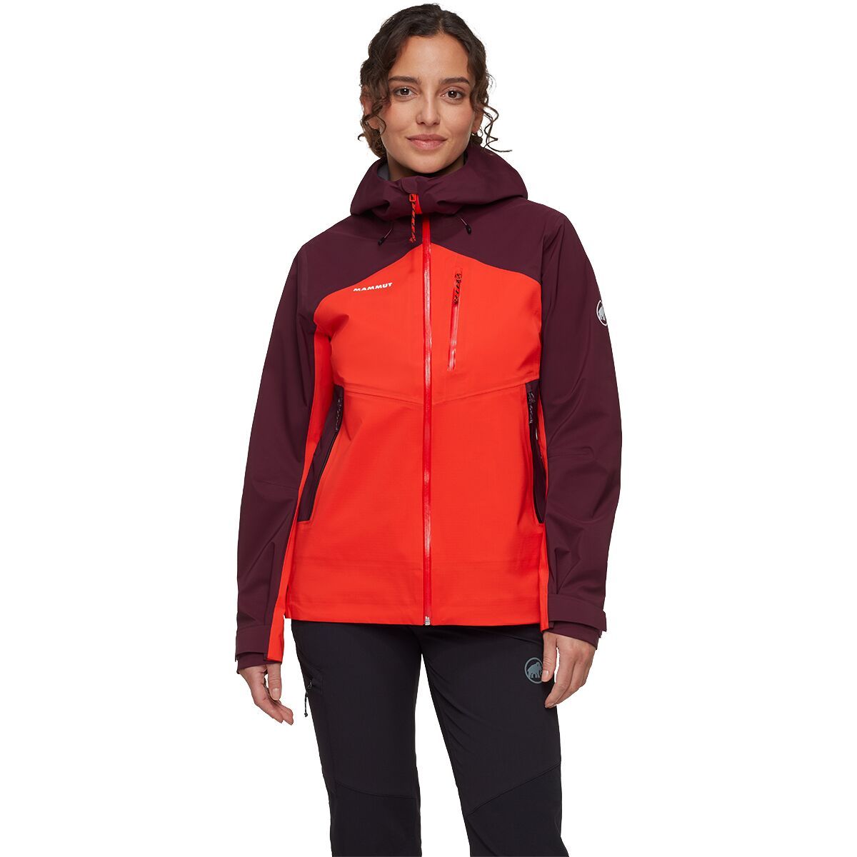
"What Our Gearhead® Experts Are Saying:""I wore the Alto Guide on a week-long trek in the Dolomites, and it handled everything from sudden squalls to long days on exposed ridgelines. The PFC-free DRY Tour fabric kept me dry without feeling clammy, and...
"What Our Gearhead® Experts Are Saying:""I wore the Alto Guide on a week-long trek in the Dolomites, and it handled everything from sudden squalls to long days on exposed ridgelines. The PFC-free DRY Tour fabric kept me dry without feeling clammy, and...

"What Our Gearhead® Experts Are Saying:""I wore the Alto Guide on a week-long trek in the Dolomites, and it handled everything from sudden squalls to long days on exposed ridgelines. The PFC-free DRY Tour fabric kept me dry without feeling clammy, and...

"What Our Gearhead® Experts Are Saying:""I wore the Alto Guide on a week-long trek in the Dolomites, and it handled everything from sudden squalls to long days on exposed ridgelines. The PFC-free DRY Tour fabric kept me dry without feeling clammy, and...

"What Our Gearhead® Experts Are Saying:""I wore the Alto Guide on a week-long trek in the Dolomites, and it handled everything from sudden squalls to long days on exposed ridgelines. The PFC-free DRY Tour fabric kept me dry without feeling clammy, and...
))/2151146.json)
Hey hikers, backpackers, and other wilderness explorers, the National Geographic Trails Illustrated Topographic Map Guide Series is the resource you'll want in your backpack while wandering unfamiliar trails. Certified Backcountry Tough, this fold-
))/2862549.json)
Expand your skillset with Outdoor Knots: A Pocket Guide to the Most Common Knots, Hitches, Splices, andashings Book by Cliff Jacobson. Inside, you'llearn from respected outdoor writer and wilderness canoe guide, Cliff Jacobson, who teaches you ho
))/3079695.json)
Fish smarter with the help of the information packed inside the National Geographic Fishing and River Recreation Map Guide Series Maps. Each one includes detailed river maps at a scale of 1 for every half mile. At this scale, every bend and
))/3079696.json)
Fish smarter with the help of the information packed inside the National Geographic Fishing and River Recreation Map Guide Series Maps. Each one includes detailed river maps at a scale of 1 for every half mile. At this scale, every bend and
))/3222459.json)
Hey hikers, backpackers, and other wilderness explorers, the National Geographic Trails Illustrated Topographic Map Guide Series is the resource you'll want in your backpack while wandering unfamiliar trails. Certified Backcountry Tough, this fold-
))/3079687.json)
Navigate your favorite trails with the National Geographic Trails Illustrated Topographic Map Guide Series Map Bundle. Providing incredible detail, these trail maps areabeled with mileage markers and show the distance between shelters, cam
))/3079694.json)
Fish smarter with the help of the information packed inside the National Geographic Fishing and River Recreation Map Guide Series Maps. Each one includes detailed river maps at a scale of 1 for every half mile. At this scale, every bend and
))/1233116.json)
Hey hikers, backpackers, and other wilderness explorers, the National Geographic Trails Illustrated Topographic Map Guide Series is the resource you'll want in your backpack while wandering unfamiliar trails. Certified Backcountry Tough, this fold-
))/2326915.json)
Hey hikers, backpackers, and other wilderness explorers, the National Geographic Trails Illustrated Topographic Map Guide Series is the resource you'll want in your backpack while wandering unfamiliar trails. Certified Backcountry Tough, this fold-
))/3222468.json)
Hey hikers, backpackers, and other wilderness explorers, the National Geographic Trails Illustrated Topographic Map Guide Series is the resource you'll want in your backpack while wandering unfamiliar trails. Certified Backcountry Tough, this fold-
))/1233156.json)
Hey hikers, backpackers, and other wilderness explorers, the National Geographic Trails Illustrated Topographic Map Guide Series is the resource you'll want in your backpack while wandering unfamiliar trails. Certified Backcountry Tough, this fold-
))/3222466.json)
Hey hikers, backpackers, and other wilderness explorers, the National Geographic Trails Illustrated Topographic Map Guide Series is the resource you'll want in your backpack while wandering unfamiliar trails. Certified Backcountry Tough, this fold-