
))/3222467.json)
Hey hikers, backpackers, and other wilderness explorers, the National Geographic Trails Illustrated Topographic Map Guide Series is the resource you'll want in your backpack while wandering unfamiliar trails. Certified Backcountry Tough, this fold-
))/984400.json)
Navigate your favorite trails and find new ones to explore with the National Geographic National Forests Trails Illustrated Topographic Map Series. Providing incredible detail, these trail maps areabeled with mileage markers and are color
))/2326915.json)
Hey hikers, backpackers, and other wilderness explorers, the National Geographic Trails Illustrated Topographic Map Guide Series is the resource you'll want in your backpack while wandering unfamiliar trails. Certified Backcountry Tough, this fold-
))/3079694.json)
Fish smarter with the help of the information packed inside the National Geographic Fishing and River Recreation Map Guide Series Maps. Each one includes detailed river maps at a scale of 1 for every half mile. At this scale, every bend and
))/1754600.json)
Navigate your favorite trails and find new ones to explore with the National Geographic National Forests Trails Illustrated Topographic Map Series. Providing incredible detail, these trail maps areabeled with mileage markers and are color
))/1754548.json)
Navigate your favorite trails and find new ones to explore with the National Geographic National Forests Trails Illustrated Topographic Map Series. Providing incredible detail, these trail maps areabeled with mileage markers and are color
))/1656093.json)
Navigate your favorite trails and find new ones to explore with the National Geographic National Forests Trails Illustrated Topographic Map Series. Providing incredible detail, these trail maps areabeled with mileage markers and are color
))/2000703.json)
Navigate your favorite trails and find new ones to explore with the National Geographic National Forests Trails Illustrated Topographic Map Series. Providing incredible detail, these trail maps areabeled with mileage markers and are color
))/3222466.json)
Hey hikers, backpackers, and other wilderness explorers, the National Geographic Trails Illustrated Topographic Map Guide Series is the resource you'll want in your backpack while wandering unfamiliar trails. Certified Backcountry Tough, this fold-
))/2028186.json)
Navigate your favorite trails and find new ones to explore with the National Geographic National Forests Trails Illustrated Topographic Map Series. Providing incredible detail, these trail maps areabeled with mileage markers and are color
))/3665183.json)
An easy-to-use power source for all your outdoor activities and more, Cabela's Outdoorsman Series 5,000W/4,000W RV-Ready Dual-Fuel Portable Generator with Electric Start and CO Shield delivers power you need, where you need it. Perfect for p
))/984408.json)
Navigate your favorite trails and find new ones to explore with the National Geographic National Forests Trails Illustrated Topographic Map Series. Providing incredible detail, these trail maps areabeled with mileage markers and are color
))/1754553.json)
Navigate your favorite trails and find new ones to explore with the National Geographic National Forests Trails Illustrated Topographic Map Series. Providing incredible detail, these trail maps areabeled with mileage markers and are color
))/2028187.json)
Navigate your favorite trails and find new ones to explore with the National Geographic National Forests Trails Illustrated Topographic Map Series. Providing incredible detail, these trail maps areabeled with mileage markers and are color
))/4194965.json)
GHG Finisher Series Foam Filled Electronic Ripple Makers- Ultra-realistic detail anatomically perfect body- Foamed-filled decoy body for durability- Built-in quiver adds realistic ripples and motion in spread- Internal watertight battery housing (4AA
))/2151883.json)
Navigate your favorite trails and find new ones to explore with the National Geographic National Forests Trails Illustrated Topographic Map Series. Providing incredible detail, these trail maps areabeled with mileage markers and are color
))/1233116.json)
Hey hikers, backpackers, and other wilderness explorers, the National Geographic Trails Illustrated Topographic Map Guide Series is the resource you'll want in your backpack while wandering unfamiliar trails. Certified Backcountry Tough, this fold-
))/3079697.json)
Fish smarter with the help of the information packed inside the National Geographic Fishing and River Recreation Map Guide Series Maps. Each one includes detailed river maps at a scale of 1 for every half mile. At this scale, every bend and
))/1233156.json)
Hey hikers, backpackers, and other wilderness explorers, the National Geographic Trails Illustrated Topographic Map Guide Series is the resource you'll want in your backpack while wandering unfamiliar trails. Certified Backcountry Tough, this fold-
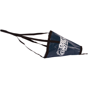
The Drift Control Fisherman Series Drift Sock is a critical tool for anglers seeking to maintain precise control over their boat's drifting speed, especially in wind or current. This Lindy Fisherman Series Drift Sock helps you stay longer in the strike...
))/3495314.json)
Culpritures unleashes premium soft-plastic performance with the introduction of the Culprit Blackabel Max Series Worm. Molded withaser-cut precision to exacting specifications, these elite Culprit worms generate superior kick, along with a bala
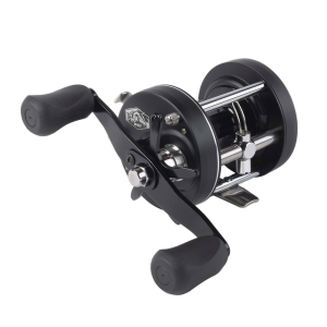
The Whisker Seeker Seeker Series 60 Casting Reel gives catfish anglers dependable power for drifting cut bait, anchoring on deep river bends, or pitching rigs around logjams thanks to a machined 6061-T6 one-piece aluminum spool and a multi-component aluminum...
))/4037742.json)
Show your pride with the Valley Forge Flag Presidential Series US Flag. This flag is made of sewn nylon that's resistant to water and dries fast. The sewn stripes and embroidered stars have a quality appearance. The canvas header features b
))/3797768.json)
Ready to troll right out of the package, each Shortbus Flashers Super Series Flasher is rigged with quality Bead-Chain ball-bearing swivels and duolock snaps, for maximum flash with minimaline twist. For use in both fresh- and saltwater. R
))/3501960.json)
Monster walleye, beware. The Reef Runner Reef Stalker 900 Series has your number. Even in dingy water, you can't escape its presence. This big, straight-bodied deep runner is fitted with Reef Runner's proven bill, so it'll run true out of th